
National Register of Historic Sites and Historical Markers
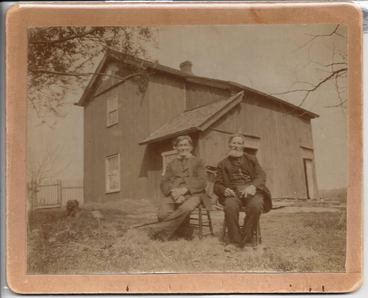
Aslak Lie Cabin
|
This map shows our area's listings on the National Register of Historic Places, the National Register of Natural Landmarks and historic site markers. Historical markers are erected by the Wisconsin Historical Society, Dane County Historical Society, as well as others. Clicking on an icon takes you to images, links to road views as well as links for offsite information pages*.
(*NPS web server is having intermittent outages in their searches). Details: Click Details at top left for description project
Legend: Click for list of map attributes Layers: Click Layers - first at top right to turn on and off layers/icons. Icons: Click an icon for information, links, and scroll down for images. Background: Use Basemap second of top right to change map background Zoom: Use + and - icons at top left or your mouse wheel Move: Click and holding anywhere on the map and move. (See complete listing (links with limited information) of sites below the map as well as resources used.) |
|
Interactive Map Details: click icon for information and link to web page. To return to map click map or <- at upper left corner. For road view click ->. Zoom: Use mouse wheel or + - icons. Move map: click and hold any open space on the map then move your mouse. Legend: Click icon at upper left corner. Click "All Items" for site lists and links. To close click map. Full Screen: Click icon at upper right corner. |
|
National Historic Register Places and Natural Landmarks
|
Daleyville, Perry Township
Hauge Log Church Onon B. and Betsy Dahle House Guibrand and Bertha Jensvold House |
Springdale Township
John Sweet Donald Farmstead Aslak Lie Cabin Eric and Jerome Skindrud Farm Black Earth Township Heiney's Market |
Historical Markers
|
Blue Mounds Township
Brigham Park German Valley Blue Mounds Fort Brigham Township (Iowa Co.) Army Cargo Plane Crash |
Black Earth
Patron's Mercantile Co-op Cross Plains (Black Earth Township) Haney's Tavern Mount Horeb Old Town |
Springdale Township
Springdale Lutheran Church Pioneer Scottish Settlement Donald Park Vermont Township Elvers Corners Peculiar Corners Vermont Creek |
|
RESOURCES: Wisconsin Historical Society Dane County Historical Society Wisconsin Historical Markers Historical Marker Database National Register of Historic Places - National Park Service National Register of Natural Landmarks - National Park Service |
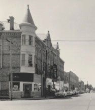
Mt. Horeb Opera House block
|