
PRAIRIE FARMER'S HOME & COUNTY DIRECTORY - DANE COUNTY, WI - 1928
|
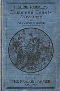
Prairie Farmer's Home and County Directory of Dane County was published in 1928 by the well known agricultural magazine, Prairie Farmer. With headquarters in Chicago, Prairie Farmer expanded in 1928 to include the Chicago radio station WLS which the magazine owners purchased from Sears, Roebuck and Company. This year also saw the magazine expanding out of Illinois and Indiana and into the surrounding upper Midwest. (Prairie Farmer continues to be published by a New Zealand company that owns a number of ag publications.)
The Home and County Directory was an ambitious project involving Prairie Farmer employees going door-to-door and filling out a questionnaire. They collected an astounding amount of information about all the resident farmers, their wives (with maiden names!), farm partners, children (including those who no longer lived at home) and where the farm was located (township and section) as well as post offices and telephone exchanges. They noted each farm's acreage, name if given, and whether it was owned (O) or rented (T for tenant.) They even listed the owner of the rented acreage. The staff then went back to Chicago and with typewriters produced this book. |
In addition to all the farm information, the Directory contains another section with a comprehensive list of farmers with pure bred livestock (both for use and for sale.) The livestock farms are organized by type of stock – dairy, beef, sheep, chickens, etc – and under each type, the specific breeds of livestock being raised – Holstein, Brown Swiss, Milking Shorthorn, etc. It is a phenomenal list of the genetic diversity existing on Midwestern farms before “improvements” in agriculture began to dramatically narrow that diversity.
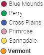
We extracted the Directory's information for southwestern Dane County including the townships of Blue Mounds, Perry, Primrose, Springdale, Vermont and the southern 1/3 of Cross Plains (sections 13-36) and made a condensed version available online in an alphabetic list of names as well as a map by section. We also have lists of the farmers and the purebred livestock they raised. Links to these illustrated livestock lists can be found in the summary of statistics at the bottom of this page. (To view the complete 1927 township plat map, click on the above township names).
A complete searchable database version of the Directory, as well as the book, is available at the MHAHS Research Center.
A complete searchable database version of the Directory, as well as the book, is available at the MHAHS Research Center.
Online Information
The “Condensed Version” of the 1928 Prairie Farmer's Directory is a chart with 5 columns:
1. Farm operator's name (last name, first name)
2. Wife's name* with her maiden name or a farm partner
3. Name of the township where the farm is located
4. Section number within that township
5. List of the children of that family
* If a widow is the farm operator, she is listed in the first column and her maiden name is usually listed in the second.
Click on a letter of the alphabet below for the “Condensed Version” chart by family last name.
Interactive map: Shows, for a selected section, a list of the farmers from the "Condensed Chart" above and a 1927 plat map with owners names. (By noting the section from the the alphabetic list above, you can see other farmers in that same section and the location of the residence.**)
|
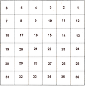
Each dot on the map corresponds to one of the numbered sections in each township. The sections are numbered with 1 at the top right corner to 6 at the top left, 7 below the 6 to 12 below the 1, etc.
So, if you wanted to see a farm in section 3 of Blue Mounds township, you would click on the blue dot, third from the right, on the top row.
Use your mouse to move the map. Use <- to return to previous views.
|
|
|
Interactive Map
Details: click icon for information. To return to map click map or <- at upper left corner. For road view click ->.
Zoom: Use mouse wheel or + - icons.
Move map: click and hold any open space on the map then move your mouse.
Legend: Click icon at upper left corner. Click "All Items" for site lists and links. To close click map.
Full Screen: Click icon at upper right corner.
**The image you see when you click on a dot is the list of names of section residents from the 1928 Prairie Farmer's Directory and the section as it looked in the 1927 Plat Map of Dane County. NOTE: If the name you are looking for does not appear on the Plat map, it means the family might be renters (the Plat map shows only owners) or that the family arrived after 1927. The MHAHS Research Center holds the 1928 Tax Rolls for each township (except Cross Plains) and can be of further assistance in locating the family farm.
Statistics:
Allowing for errors both in the original document and its transcription, these are some interesting statistics:
1. Total Rural Residences (farms and agricultural industry but not rural villages) – 873
Blue Mounds – 170
Cross Plains (sec. 13-36 only) -88
Perry – 168
Primrose – 134
Springdale – 164
Vermont - 146
2. Children - 2753 in 696 families, average 4 per family, largest number in one family - 16
3. Other permanent residents in household who were not a wife, children or farm partner (someone like a elderly parent) - 127
4. Tenant residents (some have both rented and owned property) - 302
5. Owner residents (some have both rented & owned property or with partners)- 523
6. Residents with no land (e.g. Cheesemakers, employee, etc.) - 61
7. Residences with telephones - 746
8. Farms with female heads of household - 36 (all were widows)
9. Years living in Dane County - average 32+, longest 77 years
10. Acreage used by 811 farmers - average 156, total 126,738 acres
11. Types of pure bred livestock farms: (The links have a list of the type of livestock and the farmers who raised them. There is also a brief description and photographs of many of the various breeds).
Dairy Cattle - 456
Beef Cattle - 13
Chickens - 210
Hogs - 36
Sheep - 8
Other livestock and products not listed above - 17
Farms with no purebred livestock - 349
Farms with 2 purebred livestock types - 148
Farms with 3 purebred livestock types - 22
Farms with 4 purebred livestock types - 6