ONLINE RESOURCES
Our mission is to share the information of Southwestern Dane County and the Driftless Area of Wisconsin in our Driftless Historium museum and Archives as widely as possible. To that end we have made these resources available here. There are still many good reasons to plan a visit to see additional resources that may be of interest to you.
Click here to access the Driftless Historium's Research Center hours or to make an appointment.
Click here to access the Driftless Historium's Research Center hours or to make an appointment.
Use these quick links to our resources or see the brief descriptions, images and links below.
|
PEOPLE
1928 Prairie Farmer's Directory
Civil War Early Settlers in the vicinity of Donald Park William E. Keithley, US Marine Corps COMMUNITIES MUSEUM COLLECTIONS
|
SITES
Century Farms
Cemeteries Cheese Factories Churches Interactive Combined Map (Cheese factories, Churches, Cemeteries) Miller Report: Mt. Horeb, an Intensive Survey of the Historic Resources of the Commercially-zoned Downtown Mills National Historic Landmarks and Historic Markers Post Offices Schools |
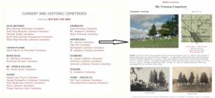
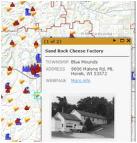
CHEESE FACTORIES, CHURCHES, CEMETERIES and SCHOOLS of Southwestern Dane County. We have created an inventory of each of these sites with links to webpages containing (when available) current and historic information including brief histories, photographs, plat maps, and offsite links.
New information is added as it becomes known. Below are the methods to access this information.
New information is added as it becomes known. Below are the methods to access this information.
|
1. Pages with a brief discussion of these subjects and a listing by Township/Village linking to the individual site's webpage.
CHEESE FACTORIES CHURCHES CEMETERIES SCHOOLS |
|
|
2. INTERACTIVE COMBINATION MAP showing the relationship and clustering of the four different subjects to one another and their almost even distribution over our area. Clicking an icon will show a photograph, some information, and a link to the site's detailed webpage.
|
|
|
CENTURY FARMS interactive map with information and images of our area's Wisconsin designated Century Farms.
|

|
|
CIVIL WAR. Included is a brief description of our area's participation, listings of soldiers in alphabetical order or by their residence at the time they entered the conflict. Also included is a list
of those who served from the Service Record Book of Men and Women of
Mount Horeb Wis. and Community published by the Frank E. Malone Post
No. 113, American Legion (c.1950), regimental histories from The Military History of Wisconsin, E.B. Quiner, 1866, and summary of statistics.
|
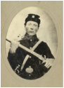
Lars Olson (Dokken)
|
|
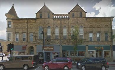
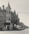
Miller Report. Mount Horeb, Wisconsin: An Intensive Survey of the Historic Resources
of the Commercially-zoned Downtown. In August 1995, The Village Board of the Village of Mount Horeb enacted a Historic Preservation Ordinance (HPO). The HPO created a five-member Historic Preservation Commission with the power to recommend designation of historic structures, historic sites and historic districts within Village limits. At about the time the HPO was adopted; the Mount Horeb Chamber of Commerce approached Elizabeth L. Miller, a historic preservation consultant, and requested general information about conducting an intensive survey of the village including all portions of downtown that is zoned C-4 (Central Commercial District). The appendix lists by address the conclusions of the Miller Report. This appendix is now available here with current and, in some cases, historic pictures. More information and pictures will be added when it becomes available. |
|
|
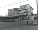
Mills. Listing and details on the grist, saw, and woolen mills of our area with an interactive map.
|
|
|
POST OFFICES listed by township/village and on an interactive map. Both link to webpages containing the post office history, images, plat maps, and road views.
|

|
|
NATIONAL HISTORIC LANDMARKS and HISTORICAL MARKERS.
An interactive map showing the sites and markers of our area with road views and links to descriptive websites. |
|
|
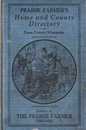
1928 PRAIRIE FARMER'S DIRECTORY. A detailed look at our area's rural living in 1928.
Lists of farmers, wives (including maiden names), children, locations, livestock and more. Research a particular rural home, family histories, and even now-rare livestock. Access by last name or township section (interactive map) or livestock type. Complete searchable database and book are available in our Research Center. |
|
|
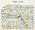
1873 PLAT BOOK's brief histories of Dane County and our six townships.
Plat books contain more that just maps. Read the history as it was written in 1873. |
|
|
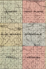
COMMUNITY HISTORIES - 6 Area Townships (Vermont, Cross Plains, Blue Mounds, Springdale, Perry, Primrose) and 8 Area Villages and Settlements (Mt. Horeb, Mt. Vernon, Daleyville, Riley, Klevenville, Pine Bluff, Blue Mounds, Forward) of Southwestern Dane County, Wisconsin.
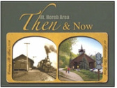
From: “Mt. Horeb Area Then & Now,” published in 2011 by the
Mt. Horeb Area Historical Society. Book is available at our Gift Store. |
|
|
|
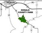
EARLY SETTLERS, LAND OWNERS and RESIDENTS, TOWN of SPRINGDALE in the VICINITY of DONALD PARK by Charles C. Gerhards of Verona. |
|

Like us on Facebook. View many of our historic photographs and share your comments.
FINDING GUIDES to our Archival Collection (coming soon)